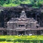
Short Description Long before “smart cities” and “urban design” became buzzwords, South India had already built them in granite, gopurams, and geometry. Dravidian temple towns like Madurai, Srirangam, and Thanjavur weren’t just religious sites; they were meticulously planned urban ecosystems. These spaces integrated spirituality with trade, social order, water management, and art turning divine devotion …
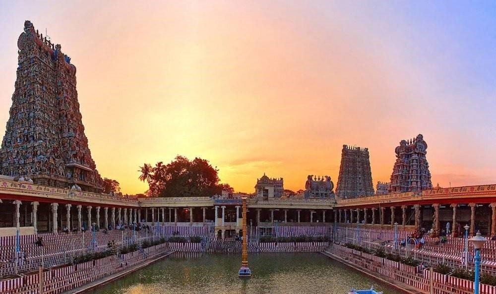
Table of Contents
- Short Description
- Sacred Geometry Meets Civic Order
- The City as a Temple, the Temple as a City
- Madurai: The Cosmic City of Meenakshi
- A City Built Around a Goddess
- Hierarchy in Stone and Street
- Economic and Cultural Epicenter
- Srirangam: The Island City of the Divine
- A Fortress of Faith
- Urban Design Through Devotion
- The World’s Largest Functioning Temple Complex
- Thanjavur: The Chola Blueprint
- The Axis of Empire
- Hydrology and Architecture
- Kanchipuram: The Multi-Temple Metropolis
- Spatial Logic of Multiplicity
- Sustainability by Design
- Vijayanagara: The Temple City as Empire
- Temples as Economic Engines
- Infrastructure for the Divine and the People
- Temple Towns as Proto-Smart Cities
- Spatial Hierarchies and Human Order
- Festivals as Urban Activation
- Sculpture, Symbolism, and the Public Realm
- Enduring Lessons for Modern Urbanism
- Conclusion: The Sacred Blueprint of Civilization
Short Description
Long before “smart cities” and “urban design” became buzzwords, South India had already built them in granite, gopurams, and geometry. Dravidian temple towns like Madurai, Srirangam, and Thanjavur weren’t just religious sites; they were meticulously planned urban ecosystems. These spaces integrated spirituality with trade, social order, water management, and art turning divine devotion into civic design. In essence, these temple cities were ancient India’s masterclass in urban planning with better sculptures, more shade, and far fewer zoning meetings.
Sacred Geometry Meets Civic Order
The Dravidian temple wasn’t a standalone structure it was the nucleus of a living city. In the southern Indian imagination, the divine wasn’t distant; it was domesticated, woven into everyday life. The temple acted as the physical and metaphysical center the axis mundi around which the rest of the city was organized.
The Dravidian planning tradition grew between the 7th and 17th centuries CE under dynasties like the Pallavas, Cholas, Pandyas, and Vijayanagara rulers. These kingdoms saw temple construction as both an act of devotion and a demonstration of power. But beyond grandeur, there was method an architectural intelligence rooted in the agama shastras (sacred architectural treatises) and vastu shastra (principles of spatial harmony).
These texts didn’t just prescribe the temple’s design; they laid out the urban logic from the placement of water tanks and markets to residential quarters and processional routes. Each street, gate, and gopuram was a thread in a vast cosmic web, balancing the spiritual and the civic.
The City as a Temple, the Temple as a City
In Dravidian urbanism, the city was a temple in miniature, and the temple was a city in essence. The temple’s spatial hierarchy mirrored the city’s social and functional order moving from the sacred center to the bustling peripheries.
- The Garbhagriha (sanctum) was the metaphysical core like the “downtown” of divinity.
- The Prakaras (enclosures) radiated outward, each ring representing decreasing sanctity but increasing accessibility akin to urban zones.
- The Gopurams (gateway towers) served as both religious thresholds and urban landmarks functioning like high-rise signage that could be seen miles away.
- The Tank (Pushkarini) provided not just ritual purity but also water management an early public utility.
This nested structure ensured that every element of urban life trade, governance, art, and worship revolved around the temple. It was a theocratic city model, but one that was surprisingly practical and inclusive.
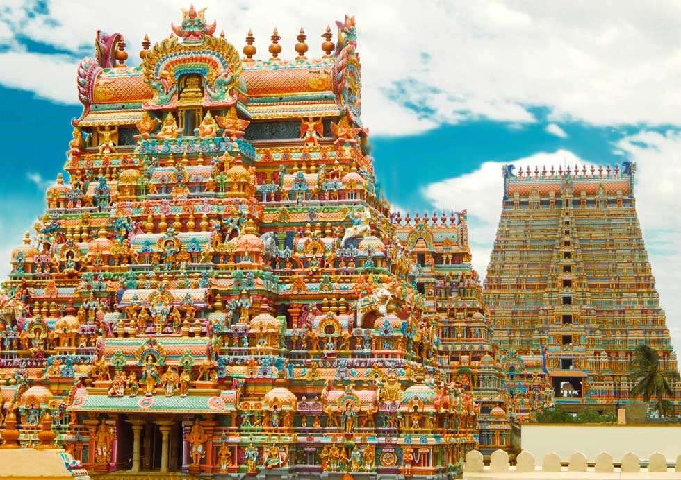
Madurai: The Cosmic City of Meenakshi
If one were to pick a single example of a temple town that exemplifies Dravidian urban genius, Madurai would win hands (and gopurams) down.
A City Built Around a Goddess
Madurai’s plan is a perfect mandala. At its center lies the Meenakshi Amman Temple, dedicated to Goddess Meenakshi (an incarnation of Parvati) and Lord Sundareswarar (Shiva). The temple is not merely a place of worship it’s the city’s heart, both symbolically and spatially.

The urban plan radiates outward from this sacred nucleus, with concentric streets encircling the temple a living metaphor for cosmic order. Each street corresponds to the path of the annual processional festivals, where deities are carried around the city, reaffirming the divine presence in civic life.
Hierarchy in Stone and Street
Madurai’s streets form a series of nested squares, each larger than the last. The innermost streets were reserved for priests and temple officials; the outer rings hosted merchants, artisans, and commoners. This layout subtly mirrored both spiritual and social hierarchies yet also encouraged constant interaction between them.
The Aadi Street, Chithirai Street, Avani Moola Street, and Masi Street create a rhythmic pattern functioning as both sacred processional routes and bustling market avenues. The temple’s economic magnetism ensured that the city around it remained alive 24/7 centuries before the term “mixed-use zoning” existed.
Economic and Cultural Epicenter
The Meenakshi Temple was a microcosm of Madurai’s economy. It owned lands, employed thousands, and acted as a banking institution. Artisans carved sculptures, weavers supplied temple cloth, musicians performed rituals creating a vibrant local economy centered around devotion.
Even the architecture encouraged commerce. The temple corridors were lined with shops an ancient version of covered bazaars where sacred and secular transactions coexisted. You could buy flowers for worship, hear a musician tuning a veena, and watch pilgrims negotiate prices all within sight of the sanctum.
In a sense, Madurai anticipated the modern concept of urban multifunctionality spiritual, economic, and cultural networks woven into one seamless plan.
Srirangam: The Island City of the Divine
If Madurai is the mandala in motion, Srirangam is the mandala perfected in geometry. Situated between the Kaveri and Kollidam rivers, this temple city is both a physical and spiritual island one of the most astonishing examples of religious urban planning in the world.
A Fortress of Faith
The Ranganathaswamy Temple, dedicated to Lord Vishnu reclining on the serpent Adisesha, forms the city’s core. Surrounding it are seven concentric enclosures (prakaras) each with its own walls, gates, streets, and functions. The entire layout resembles a cosmic diagram the earthly embodiment of Vaikuntha, Vishnu’s celestial abode.
Urban Design Through Devotion
Each enclosure in Srirangam corresponds to a distinct urban zone:
- The innermost prakara houses the sanctum, accessible only to priests.
- The intermediate prakaras contain subsidiary shrines, kitchens, and administrative offices.
- The outer prakaras host residential neighborhoods, markets, schools, and water tanks.
This graded spatial hierarchy created a seamless integration between sacred and civic life. The temple didn’t sit apart from the city it was the city. Even the walls served multiple purposes: defense, processional paths, and visual framing for the towering gopurams.
The World’s Largest Functioning Temple Complex
Spanning 156 acres, Srirangam is often described as the world’s largest functioning Hindu temple. But more importantly, it’s a living urban organism. The city’s streets align precisely with the temple’s axes, maintaining ritual symmetry across centuries of expansion.
The Rajagopuram, standing 73 meters tall, anchors the skyline a civic as well as spiritual landmark visible from miles away.
Festivals like Vaikunta Ekadasi transform Srirangam into a massive, participatory city with temporary markets, guesthouses, and procession routes activated in sync with cosmic timing. It’s urban design as living theater where divine movement dictates civic rhythm.
Thanjavur: The Chola Blueprint
If Madurai and Srirangam represent ritual and geometry, Thanjavur embodies imperial vision. The Brihadeeswarar Temple, built by Raja Raja Chola I in the 11th century, was not just a religious monument it was an architectural manifesto of Chola urbanism.
The Axis of Empire
Unlike other temples embedded within towns, Brihadeeswarar stood at the heart of a planned royal complex, surrounded by administrative buildings, granaries, and artisan quarters. It represented the Chola idea that divine and political power were one and the same a union of temple and state.
The temple’s towering vimana (superstructure), soaring over 66 meters high, was visible across the plains a symbol of centralized authority and cosmic order. Around it grew a carefully planned settlement that included palaces, gardens, irrigation tanks, and road networks radiating outward much like a modern capital city.
Hydrology and Architecture
Thanjavur’s design integrated temple tanks and canals into the urban ecosystem. The Sivaganga tank, for instance, wasn’t merely ritual; it was part of an extensive water management system that sustained agriculture and trade. The Cholas viewed water as sacred infrastructure ensuring both spiritual and material prosperity.
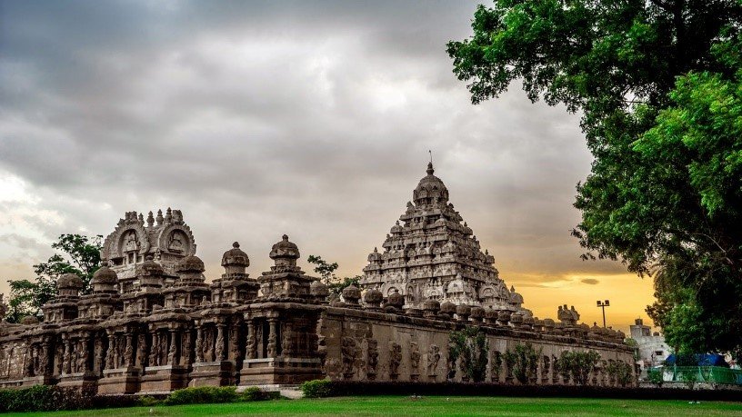
Kanchipuram: The Multi-Temple Metropolis
Before Madurai and Thanjavur, Kanchipuram was the Pallava capital a city that pioneered the concept of temple-centered urbanism. Known as the “City of a Thousand Temples,” Kanchipuram demonstrated how multiple temples could coexist as nodes within a single sacred network.
Spatial Logic of Multiplicity
Unlike monolithic temple cities, Kanchipuram’s layout revolved around several major shrines notably the Kailasanatha Temple and the Ekambaranathar Temple. Each temple served as the nucleus for its own neighborhood (agraharam), creating a city composed of many spiritual microcosms.
This plural planning model encouraged specialized economies sculptors, goldsmiths, and weavers flourished in distinct quarters serving specific temples. The city thus functioned as a polycentric urban system centuries before the term entered urban planning jargon.
Sustainability by Design
The Pallavas also perfected the use of natural topography. Temples were aligned with water bodies and processional streets oriented to capture light and airflow. Even the temple tanks doubled as flood-control systems sacred hydrology at work.
Vijayanagara: The Temple City as Empire
At its zenith in the 15th century, the Vijayanagara Empire transformed temple-centered urbanism into imperial urban planning. The capital city of Hampi remains one of the most extraordinary archaeological sites in India a metropolis built around temples, bazaars, and hydraulic networks.
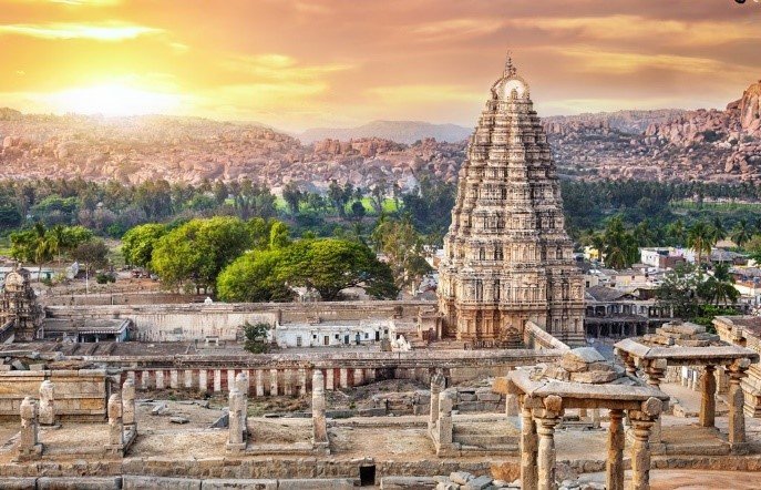
Temples as Economic Engines
The Virupaksha Temple and Vittala Temple formed the twin spiritual and commercial hubs of Hampi. Processional streets lined with colonnaded bazaars linked the sacred precincts with markets and royal enclosures. Pilgrimage routes doubled as trade arteries, ensuring that religious fervor translated directly into economic vitality.
Infrastructure for the Divine and the People
The Vijayanagara planners mastered water management constructing tanks, aqueducts, and canals that fed both agriculture and ritual needs. The integration of dams like the Kamala Puram Anicut showed an understanding of urban ecology that modern cities still struggle to match.
In Vijayanagara, the temple wasn’t merely the city’s heart it was its engine, pumping economic, spiritual, and hydraulic lifeblood through the empire.
Temple Towns as Proto-Smart Cities
If we step back, Dravidian temple towns reveal themselves as early smart cities not in digital terms, but in design intelligence. Let’s decode their brilliance:
- Integrated Planning:
Religious, economic, and residential functions coexisted harmoniously. The temple wasn’t separated from civic life; it organized it.
- Sustainable Systems:
Water tanks, rain harvesting, and natural ventilation were built into urban design. No air conditioners, no desalination plants just architectural wit and climate empathy.
- Social Networks in Space:
The city’s layout reflected social hierarchies but also facilitated mobility and interdependence. Pilgrimage routes encouraged interaction across classes.
- Economic Self-Sufficiency:
Temples managed land, trade, education, and welfare functioning as autonomous economic ecosystems.
- Cultural Continuity:
Festivals and processions continually reactivated urban spaces, ensuring that the city remained a living organism rather than a static monument.
- Information Architecture:
Gopurams were not just gateways; they were signposts and communicators broadcasting the temple’s presence across the landscape. In modern terms, they were the city’s brand identity.
Spatial Hierarchies and Human Order
The concentric organization of temple towns wasn’t random. It mirrored both cosmic and social hierarchies a worldview where urban space reflected moral order.
- The innermost zones represented purity and ritual exclusivity.
- The intermediate zones housed learned Brahmins, temple staff, and artisans.
- The outermost streets welcomed merchants, travelers, and pilgrims.
While modern sensibilities may critique this stratification, it served a functional purpose: regulating density, resource distribution, and accessibility. In its own way, it was an early experiment in zoning and land-use planning albeit one sanctioned by theology rather than bureaucracy.
Festivals as Urban Activation
No discussion of temple towns is complete without festivals the ultimate test of urban resilience. Cities like Madurai and Srirangam could host thousands of pilgrims without chaos, thanks to their expandable design.
During events like Chithirai Thiruvizha in Madurai, temporary markets, canopies, and public kitchens would emerge along predetermined streets, then disappear after the celebrations. The processional routes doubled as emergency access ways, drainage channels, and market corridors multi-purpose planning par excellence.
The festivals effectively “reset” the city reaffirming its sacred order while refreshing its civic spirit.
Sculpture, Symbolism, and the Public Realm
In modern cities, we commission murals to humanize public spaces. In Dravidian towns, every surface already spoke. Sculpture, relief, and ornamentation transformed even mundane corners into narratives political, mythological, or moral.
The gopurams were the billboards of belief, illustrating epics and cosmology. Colonnaded corridors served as public galleries. Even water tanks bore inscriptions detailing civic grants and donor records making art and administration literally carved in stone.
These were cities where the public realm was inseparable from storytelling urbanism as cultural pedagogy.
Enduring Lessons for Modern Urbanism
The Dravidian temple town model offers more than nostalgia; it provides design lessons that remain startlingly relevant:
- Center Life Around Community, Not Cars:
The temple towns prioritized walkable streets and communal gathering spaces something modern planners are rediscovering with “15-minute city” models.
- Design for Climate, Not Against It:
Orientation, materials, and shaded streets ensured comfort without machines. Sustainability was instinctive, not performative.
- Celebrate Pluralism in Form and Function:
Each temple complex integrated religion, commerce, art, and governance proving that multifunctionality enhances resilience.
- Make Beauty a Utility:
Ornamentation wasn’t wasteful; it educated, inspired, and unified communities.
Conclusion: The Sacred Blueprint of Civilization
The Dravidian temple towns were not accidents of faith they were deliberate experiments in designing a harmonious world. Their layouts combined geometry with geography, devotion with design, and ritual with reason.
Standing in Madurai’s evening light, watching the Meenakshi gopuram rise above the bazaar, one realizes that these were not mere temples but living urban blueprints cities that thought, breathed, and believed.
In Srirangam’s vast enclosures, Thanjavur’s imperial axis, or Hampi’s sacred streets, the message endures:
Urbanism, at its best, is an act of faith in gods, in people, and in the power of good design.
And perhaps, if we listen closely enough, those granite corridors still whisper a quiet challenge to modern planners everywhere:
You call it a “smart city”? We called it sacred space and it worked beautifully.